
Aerial view of Clay Farm looking south from Long Road to Addenbrooke’s Hospital and Trumpington village. Source: Oxford Archaeology East, 13 April 2011.
This is one of a series of pages about Clay Farm .
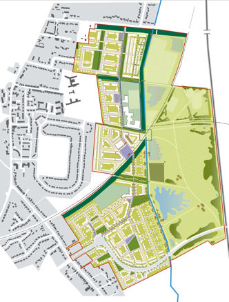
The Clay Farm and Showground development site is on the east side of Trumpington village. The overall site is 109 hectares, with Long Road to the north, the railway line to the east, the city boundary and Addenbrooke’s Road to the south, Shelford Road and the village to the west. Hobson’s Brook runs through the site from Nine Wells, in a south-north direction. The northern part of the site is called Clay Farm (the original farmhouse is near Long Road) and the southern part is called the Showground (after its use for agricultural shows in the 1940s and 1950s).

The overall plans for the Clay Farm development have been produced by Countryside Properties . The initial planning application was submitted to Cambridge City Council in October 2006, a revised application submitted in June 2007 and a further set of amendments submitted in December 2007. The proposals were approved by the Joint Development Control Committee on 14 May 2008. The outline planning agreement and S106 agreement were signed in August 2010. Individual Reserved Matters applications have followed this, for specific parts of the development.
The plan included up to 2300 residences, a secondary school, a primary school and a local centre including shops, offices and community, library and health facilities. There is a spine road running through the site from Long Road to Addenbrooke’s Road. The Guided Busway also provides public transport, linking the Park & Ride site, Addenbrooke’s Hospital and Cambridge railway station. The spine road and guided bus route intersect at Hobson Square. The area to the east of Hobson’s Brook as far as the railway line is Hobson’s Park, with open spaces, a lake/bird reserve, sports facilities and a footpath network.
The Trumpington Residents’ Association has been involved with the City Council and the developers throughout the project. The Association submitted responses as the plans were being development and continued to make responses to individual Reserved Matters as they were submitted for planning approval.
There were extensive archaeological excavations before work started on site. Countryside and Tamdown began major infrastructure work in late 2010. Individual housing areas and the other facilities are now being developed.
Countryside marketed the overall site under the name Great Kneighton . The Residents’ Association strongly disagreed with this name, which was an inappropriate and historically inaccurate name which detracted from the community’s sense of place and belonging.
Countryside itself is building homes in the Showground area in the southwest of the site, around the Addenbrooke’s Road roundabout, using the marketing name Abode . Skanska built homes south of Addenbrooke’s Road, using the marketing name Seven Acres. Bovis Homes is building homes in the area on the north side of Addenbrooke’s Road, using the name Paragon . Countryside is also be building homes in the northern area, off Long Road, using the name Aura . Cress Nicholson (Long Lane) and Hill Residential ( Virido ) also built in this area. Across each phase, 40% of the homes will be affordable housing.
See our pages for an update about work on these developments:
• Countryside Aura development, Long Road.
• Crest Nicholson Halo development, Long Road.
• Hill Residential Virido development.
• Countryside Abode development.
• Skanska Seven Acres development.
• Bovis Homes Paragon development
• Cala Homes
Road and building names on Clay Farm, some names apply across two development areas (see the Local History Group for the derivation of the names):
Abode
Hobson Avenue
Royal Way, including Southwell Building
Glanville Road
Chaplen Street
Hobson Road
Addenbrooke’s Road, including The Williams Building, The Cherry Building, The Sayle Building and The Forbes Building
Austin Drive
Cornwell Road
Ellis Road
Whittle Avenue
Fawcett Road
Beyer Road
Stallan Close
Paragon
Cornwell Road
Ellis Road
Whittle Avenue
Whittington Road
Fawcett Road
Allbutt Way
Todd Street
Baker Lane
Chalkwells Way
Southwell Drive
Seven Acres
Skylark Road
Partridge Close, including Gresham House
Kingfisher Gardens, including Whittle House
Lapwing Avenue, including Raeburn House
Cala
Pinnington Close
Halo
Brook End Close
Nine Wells Road
Clay Farm Drive
Lime Avenue
Green Lane
Virido
Fowler Avenue
Drury Avenue
Dobson Way
Hartree Lane
Harradine Street
Pychard Road
Hobson Square
Aura
Lime Avenue
Seekings Close
Plantation Avenue
Whitelocks Drive
Northrop Road, including The Aura Building
Forbes Close
Clay Farm Drive
Willers Lane
Windmill Drive
Woodpecker Way
Hawkey Road
Stacey Road
Henty Close